
Updated May 7, 2026
It may be overwhelming choosing how to spend your precious hiking time during a trip to Summit County, with literally hundreds of trails to choose from. After hiking them ourselves, we have narrowed it down for you with a list of the best Summit County hiking trails with all the beauty of rivers, lakes, wildflowers and iconic views packed into shorter trails for families and those not acclimated to high altitude.
Lily Pad Lake: NOTE: There are two Lily Pad Lake trailheads, one in the Wildernest neighborhood that requires Summit Stage shuttle dropoff, and the one referenced below, just off I-70 westbound in Frisco.
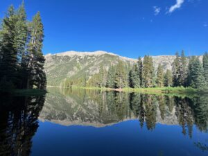
Just north of Frisco off I-70, the very popular Lily Pad Lake Trail is a 3.2-mile round trip with elevation gain of 795 feet. This is a moderately easy trail with some rocky spots along the trail. Wildflowers, babbling brooks, quaint bridges, and woodland creatures such as beavers and chipmunks are just a few sights along this path. In addition to Lily Pad Lake, you’ll have great views of Lake Dillon and Dillon Valley. Directions: Drive north on Highway 9 towards I-70 in Frisco and cross the overpass bridge. Take the second exit at the traffic circle (just before the ramp onto I-70). Drive to the end of the road into the ample parking area. Follow the sign to the Meadow Creek trailhead and early in the trail go right at the junction to Lily Pad Lake at the wooden forest sign.
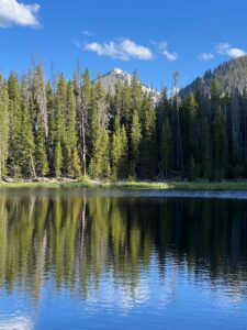
Lily Pad Lake
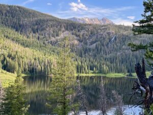
Acorn Creek Loop: We’re sorry to say, due to overwhelming popularity, the Loop (an unofficial and not well-marked trail) closed last summer in 2025. We are not yet sure what summer 2026 holds for the loop portion of the trail. The Acorn Creek hike is still open. Best for wildflower and fall foliage viewing with the majestic Gore Range as the backdrop. This hike is 6.6 miles, rated moderate. For a shorter hike, just go in 2.5 miles to the mountain view, and then turn back to the parking area. Directions: From Breckenridge, take the short drive to Silverthorne and go north from Silverthorne on Highway 9 for approximately 10.6 miles. Turn right onto Ute Park Road, right onto Rodeo Drive and follow the road 0.5 miles to its dead end at the Acorn Creek trailhead sign. The parking lot is big but may fill up on summer weekends.
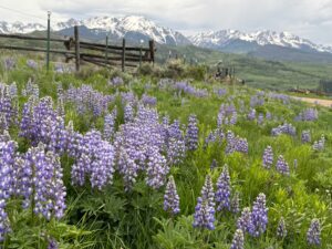
Acorn Creek Loop trail north of Silverthorne in Summit County
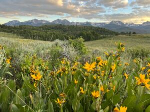
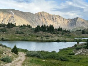
Mayflower Gulch: A favorite year-round hike. Yes, it’s even popular in the winter! This Summit County gem near Copper Mountain is 2.8 miles round trip with a gradual but gentle ascent (gaining about 600 feet elevation) on a 4wd road to an opening at the base of three majestic mountain peaks. This spot was once the site of the Boston Mine Camp with the remnants of boarding houses still standing (please be respectful and leave no trace). For Nov-Feb hikes, wear waterproof hiking boots. You will need snowshoes to prevent postholing March-April. Directions: From Breckenridge, drive to Frisco and then take I-70 west, exiting at Copper Mountain. Go south on 91 toward Leadville. Drive 5.3 miles to the parking lot on the left. For a bonus after this hike, get back on 91 going south, across the bridge and look for stunning Clinton Reservoir on your left. There is a parking area and an unofficial trail that will take you around the lake. Because this trail is unofficial, it’s sloped and branchy in spots.
Mayflower Gulch in winter
Officer’s Gulch: One of the easiest and best spots to access and navigate in Summit County. It’s a hidden gem of sorts as even the locals sometimes forget it’s there. Just off I-70 Westbound, west of Frisco, but not visible from the freeway. There is traffic noise in this spot, but go deep enough into the trail and its no longer audible. Officer’s Gulch is a small but beautiful lake surrounded by forest and mountain views. The trail is mostly flat and easy to walk on except for a few short portions where the trail dips sideways toward the lake below. Most people can navigate these short sections without issue. Follow the trail deep into the woods past the lake and along a stream until it dead ends and then return the way you came in. Directions: From Breckenridge, drive to Frisco and onto I-70 West towards Vail. Take the Officer’s Gulch exit and follow the access road to the parking area.
Officer’s Gulch on a bluebird summer day
Lower Cataract Lake: A small lake, wildflowers, and a waterfall make this a great hike for the entire family. The entire loop is 2.0 miles and considered easy with little elevation gain. While in this area, consider stopping at Green Mountain Reservoir for a picnic or a drive around the lake for the views. Directions: From Breckenridge, travel to Silverthorne and stay on Highway 9 North. Travel 16 miles and turn left onto Heeney Road and then left on Cataract Creek Road. Drive 2.5 miles to where the road dead ends at the Lower Cataract Lake parking area.
Lower Cataract Lake trail with a Gore Range peak in the background
Loveland Pass Lake: Great for kids or limited mobility: At an altitude of 11,834, Loveland Pass Lake is the only alpine lake that is super easy to access as it sits just off its namesake, Loveland Pass, going south on Highway 6 out of Keystone, past Arapaho Basin. It’s also an easy hike at 0.8 miles with only 68 feet of elevation gain. Wildflowers are abundant in summer months. Alpine lakes by themselves are beautiful regardless of the wildflowers. The trail closes during winter months. Directions: Drive south from Keystone on Highway 6 for about a half mile. The road is windy and you will need to drive carefully while looking for the parking lot on your left. If you pass the parking lot, you cannot miss the Loveland Pass Summit just around the next curve with parking on both sides. You can get out here and enjoy the summit views and then get back on Highway 6 going north to turn into the parking lot which will be on your right.
Loveland Pass Lake, altitude 11,834
Want more of the best? See Best Easy Breckenridge Hiking Trails and Friends of the Dillon Ranger District for more trail info. The All Trails app is a good resource for reviews from other hikers or guidance while hiking a trail.